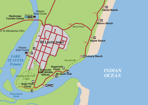
We recently visited St. Lucia in KwaZulu-Natal and quickly learned that understanding St. Lucia maps in South Africa makes exploring the area far easier. Between wildlife reserves, beaches, wetlands, and scenic drives, first-time visitors often underestimate how much there is to see. While the town itself feels relaxed and compact, the surrounding attractions stretch across a large area, making proper navigation essential for a stress-free trip.
Get To Know The Traveling Taylors!
Why You Need St. Lucia Maps in South Africa
For first-time travelers, St. Lucia maps in South Africa help simplify the entire experience. Many attractions are spread between the town center, iSimangaliso Wetland Park, Cape Vidal, and nearby safari reserves. Without a clear map, it is easy to waste time driving in circles or missing important access roads.
The best maps include:
- Beach entrances
- Wildlife viewing areas
- Boat cruise departure points
- Safari park routes
- Fuel stations and parking areas
We found that offline maps worked best because mobile signal can disappear near remote wetland zones. If you’re visiting multiple attractions throughout the day, attaching an Apple AirTag like this one to your bag or backpack can give you peace of mind in case something gets misplaced.
Best Areas to Explore in St. Lucia
One of the most useful things about St. Lucia maps in South Africa is understanding where everything sits in relation to the town center. McKenzie Street acts as the heart of St. Lucia, with restaurants, cafes, and tour offices clustered nearby.
Main Beach lies a short drive away, while wildlife reserves and scenic coastal routes spread further north and west. Many first-time visitors assume attractions are all within walking distance, but some destinations require longer drives than expected.
Having accurate St. Lucia maps in South Africa also helps travelers avoid restricted roads and identify safe driving routes inside protected wildlife areas. If you plan to rent a car, a hands-free phone mount like this one can also make it much easier to follow GPS directions safely while driving.
Best Beaches in St. Lucia for First-Time Visitors
Most travelers head straight to Main Beach, but several quieter beaches deserve attention. Mission Rocks became one of our favorite discoveries during the trip. Located inside iSimangaliso Wetland Park, it offers dramatic ocean views, rocky landscapes, and peaceful stretches of sand. Protecting your skin from the sun while at the beach is essential, and many travelers rely on SPF 50 sunscreen sprays like this one for quick and easy coverage.
Cape Vidal is another essential stop marked on many St. Lucia maps in South Africa. The drive itself feels like a safari, with zebras, antelope, and rhinos often spotted along the route. For travelers who want high-quality photos and videos during their trip, a lightweight mirrorless camera like this one is a popular choice among content creators and travel photographers.
Quick Tip: Download your St. Lucia maps in South Africa before entering wildlife parks because internet coverage becomes limited.
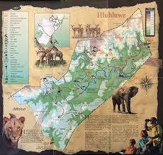
Where to See Wildlife in St. Lucia
Many travelers book a single boat tour and miss some of the best wildlife areas around St. Lucia. The estuary viewpoint near the bridge is one of the easiest places to see hippos at sunset. For a closer look, a guided hippo and croc estuary cruise is a first-timer favorite, and our guide to the best ways to see St. Lucia hippos breaks down every option.
Several smaller wetland roads shown on local St. Lucia maps in South Africa also offer fantastic birdwatching opportunities. Fish eagles, kingfishers, and flamingos are regularly spotted depending on the season.
Nearby safari areas worth marking on your map include:
- Hluhluwe–iMfolozi Park
- Eastern Shores
- Cape Vidal
- iSimangaliso Wetland Park
These locations completely transform a beach holiday into a wildlife-filled adventure. If you enjoy filming your travel experiences, a tiny wearable camera like this one is a great way to capture hands-free POV footage while walking through iconic locations.
Places to Stay in St. Lucia
Choosing accommodation becomes much easier once you study St. Lucia maps in South Africa. Travelers who prefer convenience should stay near McKenzie Street for easy access to restaurants and tour operators.
Nature-focused travelers may prefer lodges near the wetlands or properties slightly outside town. Some guesthouses even have regular hippo and antelope sightings directly outside the rooms.
Driving Tips for St. Lucia Visitors
Driving around St. Lucia is generally straightforward, but there are several important things first-time visitors should know. Hippos regularly walk through town after dark, so nighttime driving requires caution.
Keeping printed St. Lucia maps in South Africa as a backup is also smart because phone batteries drain quickly during long wildlife drives. Some travelers carry a mini portable charger like this one in their pocket or bag so they always have backup battery power for maps, photos, and ride apps.
Before setting off each day, mark:
- Petrol stations
- Park gates
- Emergency contacts
- Beach parking areas
- Food stops
These simple details make exploring the area far easier.
Final Tips for Using St. Lucia Maps in South Africa
St. Lucia offers far more than many travelers expect. With the right St. Lucia maps in South Africa, first-time visitors can confidently explore hidden beaches, wildlife reserves, scenic roads, and peaceful wetland areas without missing the highlights. Planning your routes ahead of time helps you experience the best parts of this unforgettable South African destination while avoiding common travel mistakes. For more inspiration, browse our St. Lucia South Africa adventure guide and our roundup of St. Lucia’s hidden gems on the map.


Share your thoughts with us! Leave a Comment!