

When we visited Morocco, one of the first things we realized was how important a clear Morocco map is for planning. At first glance, everything looks close together, but once you start mapping routes, the distances and terrain quickly change your perspective. Using a Morocco map properly can save hours of travel time and help you avoid unnecessary backtracking.
Get To Know The Traveling Taylors!
This Morocco map guide focuses on practical route planning so you can move efficiently between destinations without overcomplicating your itinerary. If you’re planning to visit, following turn-by-turn directions is far easier when your phone stays in view, so a secure phone holder like this one is worth adding to your kit.
Morocco Map Basics: Understanding Layout
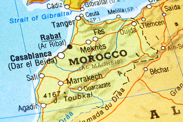
A Morocco map is easiest to understand when viewed in sections. The main travel corridor runs from the north down through central Morocco and into the desert regions.
Key cities such as Casablanca, Rabat, Fes, and Marrakech form the backbone of most routes. These are well-connected and often serve as starting or transition points. If you love documenting your adventures across the north-south route, a compact wearable camera like this one is an excellent way to capture immersive hands-free POV footage, allowing you to record every memorable moment.
The Atlas Mountains run diagonally across the country, acting as a natural divider on the Morocco map. South of these mountains, routes become more remote and require additional travel time.
Understanding this layout helps you visualize how destinations connect before building your route.
Morocco Map Routes: The Most Efficient Loop
One of the most effective ways to use a Morocco map is by planning a loop rather than a linear route. A loop allows you to see more while avoiding repeated journeys over the same ground.
A common efficient route starts in Casablanca, moves to Fes in the north, then heads south through the Atlas Mountains toward the Sahara Desert. From there, the route continues west to Marrakech before returning to Casablanca. For travelers looking to capture stunning photos and cinematic-quality videos throughout their journey, a lightweight mirrorless camera like this one is a popular choice among content creators and travel photographers thanks to its impressive image quality and portability.
This structure works well because it follows the natural flow of the Morocco map, reducing unnecessary detours and saving time.
Morocco Map Travel Times: Plan Realistically
A Morocco map can be misleading when it comes to distance versus travel time. Roads through mountains or rural areas often slow journeys significantly.
For example, a route that appears short on a Morocco map may still take several hours due to winding roads or elevation changes. Travel between major cities like Fes and Marrakech typically takes most of a day. On days that long, many travelers keep a portable power bank like this one handy so their phone stays charged for maps and music the whole way.
Building realistic expectations into your Morocco map planning ensures a smoother and less rushed experience.
Morocco Map: Connecting Key Destinations
When using a Morocco map, it’s helpful to group destinations logically. Cities in the same region should be visited together to minimize travel time.
For example, northern cities can be explored in one segment, while central and southern destinations form another. The desert portion of the Morocco map is best treated as a dedicated section due to its distance and travel requirements. The Sahara scenery is unforgettable, so if you want to bring it home in photos, a high-quality travel action camera like this is easy to carry on the drive out.
This approach allows you to move through the country in a structured way rather than jumping between distant points.
Morocco Map Strategy: Avoid Backtracking
One of the biggest inefficiencies in travel planning comes from backtracking. A Morocco map can help you avoid this by clearly showing route flow.
Instead of returning to the same city multiple times, plan your journey so each stop leads naturally to the next. This is especially important when traveling between Marrakech, Fes, and desert regions. Since you’ll be hopping between crowded stations and busy medinas along the way, a hidden money belt like this one keeps your cash and passport safe from pickpockets.
Using a Morocco map strategically ensures that each leg of your trip builds on the previous one.
Morocco Map Planning Tips That Save Time
Effective use of a Morocco map comes down to a few key principles. First, keep your route simple and avoid trying to cover too many distant locations in a short period. Second, account for terrain when estimating travel time. Third, prioritize regions rather than individual cities when planning your itinerary. This creates a more cohesive travel experience and reduces logistical complexity.
Morocco Map Guide: Plan Smarter Routes
A Morocco map is more than just a visual reference—it’s a tool that shapes your entire trip. Understanding how routes connect, how long travel takes, and how regions are structured allows you to plan with confidence. By using a Morocco map effectively, you can create a route that is efficient, well-paced, and enjoyable. With the right approach, navigating Morocco becomes far simpler, leaving you more time to experience each destination fully.
If you’re planning to visit, our guide on Morocco Rental Cars: What No One Warns You About is a smart next read before you hit those routes.