Looking at a South Africa map for the first time can feel overwhelming — beaches, bush, mountains, cities, and huge distances all in one country! We felt the same way on our first trip. So here’s our guide to the best regions to visit in South Africa, with what makes each one special and how to connect them.
Get To Know The Traveling Taylors!
Why a South Africa Map Helps You Plan
South Africa is roughly the size of France and Spain combined. So it pays to know which regions pack in what you love — safaris, wine tasting, surfing, or dramatic mountains — and how to link them smartly.
Because you’ll be visiting famous landmarks and scenic viewpoints throughout South Africa, you may want to bring a compact selfie stick tripod like this one so they can easily capture photos without asking strangers.
1️⃣ The Western Cape
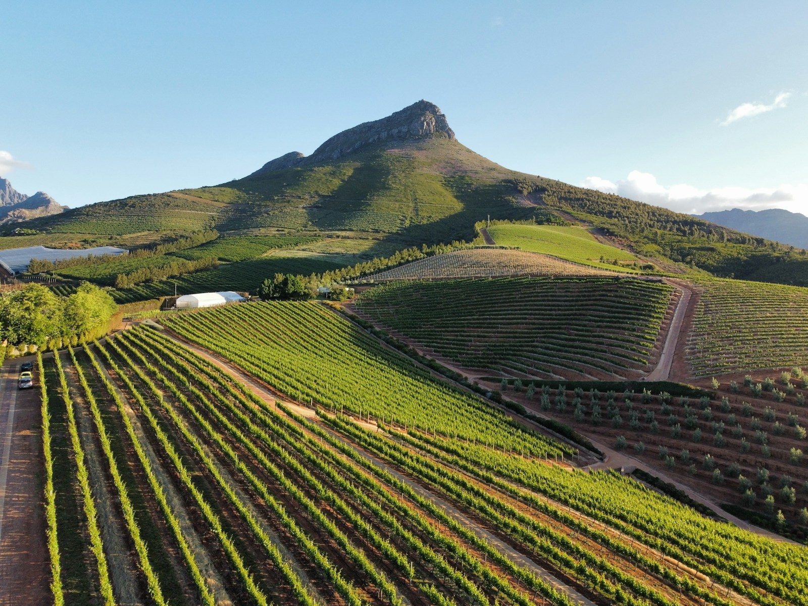
When you think of a South Africa map, this is where most first-timers start. Home to Cape Town, the Garden Route, and world-famous vineyards, the Western Cape has it all.
✅ Highlights:
- Cape Town: Table Mountain, penguins at Boulders Beach, Robben Island.
- Winelands: Stellenbosch and Franschhoek for wine tasting.
- Garden Route: A coastal stretch from Mossel Bay to Storms River — perfect for road trips.
Why go? Beautiful beaches, easy driving routes, and top-notch food scenes.
2️⃣ Eastern Cape
Slide your South Africa map east along the coast and you’ll find the rugged, less-touristy Eastern Cape. It’s a favorite for road trippers wanting wild beaches and surf towns.
✅ Highlights:
- Addo Elephant National Park: A top spot for elephant sightings.
- Wild Coast: Coffee Bay and Hole in the Wall — dramatic cliffs and untamed beaches.
- Jeffrey’s Bay: Legendary surf spot.
Why go? Fewer crowds, authentic local vibes, great for budget travelers. Enjoy the beaches along the Wild Coast and Jeffrey’s Bay but remember to protect your skin from the sun. Many travelers rely on SPF 50 sunscreen spray like this one for quick and easy coverage.
3️⃣ KwaZulu-Natal
On your South Africa map, KwaZulu-Natal is tucked on the warm Indian Ocean. Think tropical beaches, historic battlefields, and lush mountains.
✅ Highlights:
- Durban: Golden beaches, spicy Indian cuisine.
- Drakensberg Mountains: Jaw-dropping hikes and waterfalls.
- Hluhluwe-iMfolozi Park: Lesser-known safari gem.
Why go? Year-round warm weather, big Zulu culture, and easy bush-to-beach combos. Because you’ll likely be outside for hours enjoying the beaches or hiking, bringing UV-protective sunglasses like these can help keep your eyes comfortable throughout the day.
4️⃣ Mpumalanga & Limpopo
This is where your South Africa map screams safari. The country’s biggest wildlife draw — Kruger National Park — straddles these provinces.
✅ Highlights:
- Kruger National Park: Self-drive or luxury safari lodges.
- Panorama Route: Blyde River Canyon, God’s Window, waterfalls galore.
Why go? The easiest way to tick off the Big Five, plus epic scenery. Staying hydrated as you spend the day looking to spot the Big Five is important, so many travelers carry a collapsible water bottle like this one that folds flat when empty.
5️⃣ Gauteng
Often overlooked on the South Africa map, Gauteng is the urban pulse — you’ll likely land here first.
✅ Highlights:
- Johannesburg: Apartheid Museum, Maboneng Precinct, Soweto tours.
- Pretoria: Union Buildings and jacaranda-lined streets.
Why go? A dose of history, street art, and lively city culture before or after your safari. When exploring Johannesburg or Pretoria, comfortable shoes are essential, and many travelers recommend supportive walking sneakers like these for full days of sightseeing.
6️⃣ The Northern Cape
A big blank space on many a South Africa map, but so worth it for rugged landscapes.
✅ Highlights:
- Kgalagadi Transfrontier Park: Remote red dunes and big cats.
- Namaqualand: Spring wildflower carpets.
- Augrabies Falls: Thundering waterfall in a desert setting.
Why go? Wild, remote, and incredible stargazing.
How to Link South Africa Regions
✅ Classic combo: Cape Town → Garden Route → Addo → Fly to Kruger.
✅ Bush to beach: Kruger → Durban → Drakensberg.
✅ Wild card: Add Northern Cape if you love wide-open spaces and want zero crowds.
South Africa’s budget flights make hopping between regions easy — save long drives for scenic routes like the Garden Route where you can use a secure phone holder like this one so you can easily follow navigation directions while riding around.
Travel Tips for Your South Africa Map
✔️ Give yourself time: Don’t rush — distances are bigger than they look.
✔️ Pick 2–3 regions max: Better to go deep than try to see it all.
✔️ Plan for seasons: Summer (Dec–March) is great for beaches, dry season (May–Sept) is prime safari time.
South Africa Map: Your Regions, Your Adventure
So, grab a South Africa map, circle your must-sees, and build your dream route. Coastal road trips, wild safaris, city life — this country’s regions pack it all in. And we promise: once you start, you’ll be planning your next trip before you even fly home.
Related Trip Planning Reads
✅ South Africa Map Explained: Cities, Parks & Hidden Gems
✅ South Africa Kruger National Park: First-Timer’s Safari Guide
✨ Need help mapping your route? Drop us a comment at www.thetravelingtaylors.world — we love helping travelers plan the perfect South Africa adventure!


Share your thoughts with us! Leave a Comment!