
When we first looked at a South Africa map, it felt huge — beaches, deserts, cities, and safaris all crammed into one country! If you’re planning your trip, here’s a clear breakdown of what’s where, how to connect the dots, and the hidden gems most tourists miss.
Get To Know The Traveling Taylors!
How Big Is South Africa?
South Africa is bigger than you think — about the size of France and Spain combined. That means travel times can be longer than they look on a map. But don’t worry: once you know the regions, planning becomes way easier. Many travelers like carrying a lightweight backpack like this one to store essentials like chargers, water bottles, and jackets as they travel around South Africa.
South Africa Map: Must-Know Regions
Here’s how to break down your South Africa map at a glance:
✅ The Western Cape: Famous for Cape Town, the Garden Route, and winelands like Stellenbosch and Franschhoek. Rugged mountains meet turquoise beaches — plus penguins at Boulders Beach!
✅ Eastern Cape: Quieter, wilder beaches. Home to the Wild Coast, surfing towns like Jeffrey’s Bay, and Addo Elephant National Park. For travelers who want high-quality photos and videos, a lightweight mirrorless camera like this one is a popular option for documenting trips.
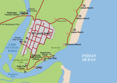
✅ KwaZulu-Natal: Durban’s warm beaches, the lush Drakensberg Mountains, and easy access to Zulu culture and battlefields.
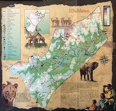
✅ Mpumalanga & Limpopo: Safari central — this is where you’ll find Kruger National Park, Blyde River Canyon, and private game reserves.
✅ Gauteng: The urban heart — Johannesburg and Pretoria sit here. Great museums, vibrant city life, and where most travelers land first.
✅ The Northern Cape: Remote and dramatic — think the Kalahari Desert, Namaqualand flowers, and stargazing in Sutherland.
✅ The Free State: Mostly farmland and rolling plains — often skipped, but interesting if you’re road-tripping through the interior.
Key Cities to Find on a South Africa Map
✅ Cape Town: Stunning coastal city under Table Mountain — beaches, food, wine, history.
✅ Johannesburg: South Africa’s biggest city and gateway to Kruger. Modern, creative, full of museums and Soweto’s famous street art.
✅ Durban: Warm Indian Ocean beaches and a big Indian-South African food scene. Great jumping-off point for the Drakensberg.
✅ Port Elizabeth (now Gqeberha): Coastal city on the Eastern Cape — gateway to Addo Elephant Park and the end of the Garden Route.
✅ Pretoria: The administrative capital, full of jacaranda trees and grand old buildings.
Top Parks & Natural Wonders on a South Africa Ma
🦁 Kruger National Park: The crown jewel — one of Africa’s best places to see the Big Five.
🐘 Addo Elephant National Park: The best spot for elephants on the Eastern Cape.
⛰️ Drakensberg Mountains: Epic hiking trails, waterfalls, and ancient rock art.
🌊 Blyde River Canyon: A lush green canyon with jaw-dropping viewpoints like God’s Window.
🐧 Table Mountain National Park: Includes the iconic flat-topped mountain plus the Cape Peninsula and Boulders Beach penguins. Protecting your skin from the sun as you enjoy these renowed places is essential, and many travelers rely on SPF 50 sunscreen spray like this one for quick and easy coverage.
Hidden Gems to Mark on Your South Africa Map
📍 Cederberg Mountains: Dramatic orange rocks, caves with ancient San rock art, and quiet hiking trails — just a few hours from Cape Town.
📍 Namaqualand: In spring (August–September), this dry region explodes with wildflowers — one of the world’s most stunning natural displays. Because you’ll likely be outside for hours enjoying the splendor of the wildflowers, bringing UV-protective sunglasses like these can help keep your eyes comfortable throughout the day.
📍 Coffee Bay: Wild Coast paradise with dramatic cliffs, surf breaks, and the iconic Hole in the Wall rock formation.
📍 Sutherland: A tiny Karoo town known for stargazing — some of the clearest skies in the Southern Hemisphere.
How to Use a South Africa Map for Planning
✅ Combine regions smartly: Many travelers link Cape Town, the Garden Route, and Addo in one coastal loop — then fly to Kruger for safari time.
✅ Don’t underestimate distances: A “short” drive on the map can take hours on winding roads — leave wiggle room in your itinerary.
✅ Look for domestic flights: South Africa has great internal flights — fly between Cape Town, Johannesburg, Durban, or Kruger to save days of driving, but if you plan to rent a car to make the drive, a hands-free phone mount like this one can make it much easier to follow GPS directions safely while driving.
South Africa Map: Now You’re Ready to Explore
Don’t let the size intimidate you — a South Africa map is your best friend for planning coastlines, safaris, and hidden gems in one epic trip. Pick your regions, connect the dots, and get ready to fall in love with the Rainbow Nation.
Related Trip-Planning Reads
✅ South Africa Kruger National Park: First-Timer’s Safari Guide
✅ South Africa Bucket List: 7 Mind-Blowing Experiences
✅ South Africa Map: Best Regions to Visit
✅ Best South Africa Cities to Visit (And Ones to Skip)
✨ Want help mapping your perfect route? Drop us a comment at www.thetravelingtaylors.world — we’d love to help you craft an adventure that checks off every corner of your map!


Share your thoughts with us! Leave a Comment!